
Satellite Data Method
Strengths of Satellite Data:
-
Covers large, continuous areas
-
Assesses riparian intactness at a watershed or regional level
-
Assesses upland pressure on riparian areas
-
Allows for comparisons between water bodies or watersheds
-
Prioritizes restoration and conservation efforts when intactness is paired with upland pressure on riparian areas

SATELLITE DATA
Satellite Data is a newer method which has become more common since 2015.
Riparian Intactness measures the extent to which natural habitat has been altered or impaired by human activity and uses 3 metrics to look at the amount of:
-
Natural vegetation
-
Woody vegetation
-
Human footprint or impact in that area
OUTCOMES
-
Creates a starting point to observe widescale riparian changes over time
-
Identifies riparian areas that need extra attention due to human impacts
-
Provides watershed-scale guidance to municipal and Non-profit programs that support landowners
-
Provides recommendations to landowners which should always be paired with on-the-ground assessment results.
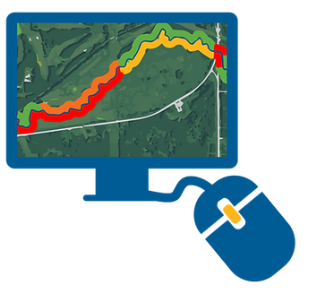
The Riparian Web Portal uses satellite data to view riparian intactness and displays the data as color-coded sections on the map.
This data needs to be analyzed and uploaded to the portal, therefore intactness data is only available on the portal if this work has been done for a particular area.
Satellite Data Method Examples
Vegetation present.
Little or no human footprint.
Vegetation present. Some human footprint.
Vegetation limited. Human footprint prevalent.
Vegetation mostly cleared. Human footprint dominant.

HIGH
INTACTNESS

LOW
MODERATE
INTACTNESS

LOW
INTACTNESS
